High-speed rail crisis persists: the golden corridor's shift from rice farming to science parks is destined to grow dim
Text by NewsMarket reporters Wang Wen-hao and Lin Hui-chen
The Executive Yuan rolled out its "one highlight per week" economic push, and last week (October 8) it served up its first dish, the "Yunlin-Changhua Golden Corridor New Agricultural Plan," which is expected to invest 3.3 billion over the next eight years to guide farmland along the high-speed rail line in the Changhua and Yunlin areas, covering 1.5 km east-west and 35 km north-south, totaling about 13,000 hectares, into "water-saving agriculture," encouraging farmers to switch from rice to dryland crops while also developing leisure agriculture, in hopes of solving the land subsidence in Changhua and Yunlin that threatens high-speed rail safety.
Three days later (October 11), the Taipei High Administrative Court ruled to revoke the development permit for the Phase 4 Erlin Park of the Central Taiwan Science Park, on the grounds that the Ministry of the Interior had failed to take into account the excessive development and idle land of science parks, and that approving the development would seriously affect food security, sustainable development and the public interest.
The Golden Corridor and the Phase 4 Central Taiwan Science Park's transformation into a low-water-use precision machinery park appear unrelated, but in fact they affect each other. Both are located in the severely subsiding Changhua and Yunlin areas, and both appear to balance economic development with environmental protection. In fact, both package a growth-at-all-costs mindset in the guise of mitigating land subsidence. The result of this mismatch between appearance and reality dooms Chu Ching-yi's "hope that the Erlin Park will be the last environmental protection versus development dispute" to failure: the land subsidence problem will be hard to solve, and the high-speed rail will remain beset by danger.
Uncontrolled park development and transport construction are the main causes of land subsidence
According to a report commissioned by the Water Resources Agency of the Ministry of Economic Affairs and conducted by Sinotech Engineering Consultants, titled "Analyzing the Direction of Land Use Based on the Relationship Between Hydrogeology and Groundwater - Changhua-Yunlin High-Speed Rail Corridor Area," the causes of land subsidence can initially be divided into hydrogeological structure, ground loading, and excessive groundwater pumping. In particular, the completion of the high-speed rail and east-west expressways, as well as the large buildings brought by industrial park development on the surface, all cause excessive surface loading that triggers land subsidence.
The Water Resources Agency investigated changes in land subsidence in the Changhua-Yunlin area, calculating cumulative subsidence over the years, and found that the subsidence center has gradually shifted from the coast inland. In particular, after ROC year 90, the main subsidence centers have been concentrated in Xizhou Township, Xihu Township and Erlin Township in Changhua County, and Huwei Township, Tuku Township and Yuanchang Township in Yunlin County. The high-speed rail passes through the Changhua-Yunlin area right through the Changhua Xizhou subsidence cone and the Yunlin County subsidence center, impacting high-speed rail safety.
The report analyzes that the total annual groundwater pumping in the Changhua-Yunlin area is 1.01 billion cubic meters, and the total pumping in the townships along the high-speed rail line in these two counties and cities is 116 million cubic meters per year, accounting for about 11.5%. Although agricultural water use remains the largest groundwater use along the high-speed rail line (65.1%), domestic and industrial large users also account for 34.9%, and large users in particular pump groundwater from greater depths, making them the greatest threat to land subsidence in the region.
In addition, according to pier monitoring data from Taiwan High Speed Rail Corporation between ROC years 92 and 99, land subsidence is most severe along the Xizhou Township section in Changhua County (high-speed rail mileage 201K to 205K) and the sections in Huwei Township, Tuku Township and Yuanchang Township in Yunlin County. These sections are located respectively at the High Speed Rail Yunlin Station special district, the intersection of Yunlin County Road 158 and the high-speed rail, and the intersection of the No. 78 east-west expressway and the high-speed rail (around high-speed rail mileage 214K to 240K, with maximum cumulative subsidence reaching 62.4 cm by 2010).
The report commissioned by the Water Resources Agency points out that the section where the high-speed rail meets the No. 78 expressway in Tuku Township, Yunlin County (mileage 224K+260 to 224K+405) has the most severe land subsidence, which should be caused by the No. 78 expressway embankment being built with fill, resulting in excessive surface loading.
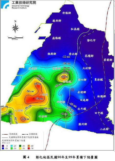 The site selected for the Changnan Science and Technology Industrial Park is near the high-speed rail and happens to be the subsidence center in Xizhou Township, Changhua County. (Source: Changhua County Government)