Forestry Bureau releases aerial footage of Wulai, stressing that collapses in national forest land are sporadic and soil and water conservation is not a problem; large-scale collapses are all outside forest compartment land
0812 News Latest Update
The Forestry Bureau's latest announced aerial photo map from the fixed-wing aircraft shows that the large-scale landslide on the upper reaches of the Dongzhakong Creek, which public opinion currently claims is causing the turbidity of the Nanshi Creek, has shrunk by about 0.8 hectares compared with 2013. The Forestry Bureau stated that the rock strata in this area are inherently quite prone to fracturing; the Forestry Bureau once carried out artificial reforestation here but landslides still occurred, so it adopted a "natural regeneration" approach, allowing broadleaf forest to grow. From the aerial photo map, it can be seen that in the shrunken area, "some vegetation has already increased," and this should not be the main cause of the turbidity of the Nanshi Creek.
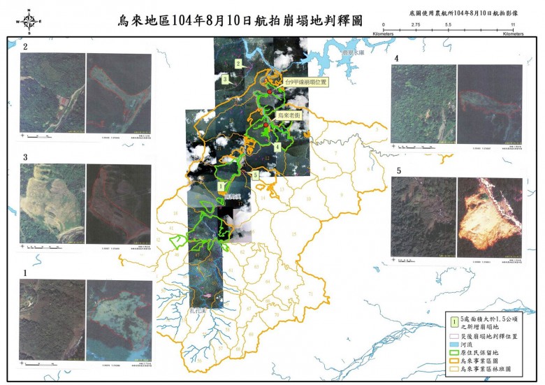
(Related aerial photos can be seen below in the pre- and post-Typhoon Soudelor aerial imagery of the landslide in the Wulai Working Circle Compartment 60)
—————————————————————————-
On the 10th, the Forestry Bureau of the Council of Agriculture dispatched the Aerial Survey Office of the Agriculture and Forestry to conduct aerial photography of the national forest compartments on the upper reaches of the Nanshi Creek, carrying out interpretation of pre-disaster and post-disaster aerial imagery. The newly added 5 landslide sites larger than 1.5 hectares, totaling about 10.38 hectares, are all not national forest land. The more severe landslide sites are mainly in Guangxing Community in Zhitan, Xindian, Zhongzhi Village, the Huanshan Trail in the Wulai Hot Spring Tourist Area, and Xinxian Village Zhong. Forestry Bureau Director Li Taosheng emphasized that Typhoon Soudelor this time caused only sporadic landslides on national forest land, implying that there is no problem with soil and water conservation on national forest land.
It is understood that at 10 a.m. on the 10th, the Aerial Survey Office began photographing progressively along the Nanshi Creek in the Guishan Township section of Xindian District toward Wulai, Fushan Village, and other places, and did not land until 1 p.m. After overnight map production and comparison with past aerial survey data, the existing landslide area in the Wulai area totals 56.89 hectares, of which 32.50 hectares are within national forest land and 24.39 hectares are on non-national forest land, and the newly added larger-scale landslide sites this time are all not within the scope of national forest land.
The total area of national forest land on the upper reaches of the Nanshi Creek is as high as 31,529 hectares, and it is the "Wulai Working Circle" under the jurisdiction of the Hsinchu Forest District Office of the Forestry Bureau, with a forest coverage rate of 97.9%. Li Taosheng pointed out that 39% of the forest land is designated as protection forest, and it is important forest land for managing the Nanshi Creek and Xindian Creek and for conserving water supply for the Greater Taipei area. (Click on the photos to view larger images)
 The Tonghou Forest Road Control Station has been in operation since August 1, 93rd year of the Republic of China (2004); after implementing total visitor volume control, it has played an important role in improving local water quality and environmental maintenance. (Photo provided by / Hsinchu Forest District Office)