Farmland: An Eternal Legacy of Earth's Cultural Heritage (Part 2)
Farmland: The Everlasting Cultural Landscape That Lies Close to the Earth
—A Look at Italy's World Heritage "Cultural Landscape of the Val d'Orcia" (Val d’Orcia) [Note 1]
[Part 2]
January 28, 2012
——————————————————————————————–
The first part discussed the two major systems of agricultural heritage. Now let us introduce this Italian case that takes the value of agricultural landscape as its foundation and has influenced the direction of cultural heritage development—the Cultural Landscape of the Val d'Orcia.
Italy is currently the country with the largest number of World Heritage sites, 47 in total, rich in variety and innovative in concept. The Cultural Landscape of the Val d'Orcia was inscribed in 2004, becoming a special case that emphasizes replacing commerce with agriculture and reviving glory through the humanities.
[Part 1]: https://www.newsmarket.com.tw/Article_Single.aspx?ID=932
Part Three. A Classic Example of World Heritage—the Cultural Landscape of the Val d'OrciaVal d’Orcia
3-1 Background of the Cultural Landscape of the Val d'Orcia
3-1-1 Introduction
The Val d'Orcia is located in the province of Siena in today's Tuscany region of Italy, encompassing five towns and their surrounding cultural landscape: Pienza, Montalcino, San Quirico d'Orcia, Castiglion d'Orcia and Radicofani. Among them, the historic centre of Pienza (Pienza, the "ideal city" rebuilt under Pope Pius II in the 15th century) was inscribed as a World Heritage site in 1996. (Figure 4)
The history of this area can be traced back in an unbroken line to prehistoric times; it already played an important role in the Roman period, and in the Middle Ages it depended on agriculture, with a number of monasteries and villages having gathered here by the 11th century. By the 13th to 14th centuries, agriculture flourished even more and the economy rose; this was the seat of the Republic of Siena, known as "the heart of Tuscany," and an important pilgrimage route, the Via Francigena (Fracigena Avenue), passed through it, linking the European interior with Rome.

Figure 4: Val d’OrciaGeographic location of the Cultural Landscape of the Val d'Orcia
Map by: H.J. Lin
Base maps: left - Nomination file of Val d’Orcia, top right - wiki, bottom right - UNESCO WHC
In Italy in the early Renaissance, five kingdoms divided the land, wars were frequent, and mercenary warlords were hired everywhere by kings willing to pay, leaving the situation in turmoil. The largest political centre was the city of Florence in Tuscany; the famous banking family, the Medici, who at the time formed a three-way balance with political and religious powers, was the key core in Florence that concentrated the ambition for power and drove artistic development.
The Republic of Siena was located to the south of the Republic of Florence. From the 14th century it implemented the so-called "Buon Govern" (called good government) system. After political stability, the Renaissance art movement also entered along with the power of the Medici family, opening the historical thread through which the Val d'Orcia was repeatedly depicted in paintings.
3-1-2 Taking pride in the historical agricultural landscape in paintings
The gently rolling hills of the Val d'Orcia are mainly chalky soil, with wheat as the main crop, along with grapes and olives. Medieval nobles had already begun to drive regional agricultural development; the Sienese families of the Renaissance period were the main feudal lords of the Val d'Orcia, choosing manor sites on high ground from which they could look down and manage, splitting the proceeds fifty-fifty with the farmers, who lived in the middle of the fields and did not need to move into the city.
The living-space system on the pastoral land: manors, small farmhouses, barns and courtyard walls, all rural in form and material. In times of peace and prosperity, no fortresses were seen on the farmland, the tenant lord's manor stood alone, farmhouses were scattered among the fields, land outside the city was planted according to planning, important buildings were built along the pilgrimage route, and appropriate crops were planned around them.
Unlike the medieval landscape, this new agriculture and new landscape belonging to the Renaissance period arose in dependence on the social system of the time and is highly rich in cultural meaning (Figure 5).

Figure 5: The gently rolling hills of the Val d'Orcia are mainly chalky soil, with wheat as the main crop, along with grapes and olives. This is a new agriculture and new landscape of the Renaissance period, highly rich in cultural meaning.
Source: wiki
Painters of the Renaissance sought to break away from the Byzantine brushstroke and began to take natural landscapes as their subject, and these landscape features began to appear in many paintings. Figure 6 is a work by A. Lorenzetti (1293-1948) depicting the city of Siena, showing the state of land use under the "good government" system, in which it is clearly visible that the land between towns had already been planned and planted with crops.
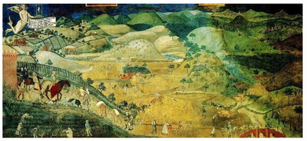
Figure 6: Ambrogio Lorenzetti depicts the city of Siena
Source: http://www.artflakes.com/en/products/a-dot-lorenzetti-buon-governo-landschaft
Figure 7 is a 1449 painting by Sano di Pietro (1406 – 1481), in which shepherds on the hills receive the angel's announcement, the roads on the land have been planned, and the crops and land appear well tended.
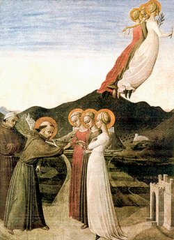
Figure 8 is a work by the painter Sassetta (1392-1450), Le nozze mistiche di S. Francesco con la Povertà, in whose background a large amount of orderly farmland also appears. These pictorial presentations coming down through history are the source of local residents' self-identification.
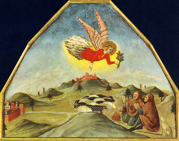
Left - Figure 7: painting by Sano di Pietro
Source: http://serena-ilsuospazio.blogspot.com/2011/12/la-nativita-raffigurata-da-pittori_17.html
Right - Figure 8: work by Sassetta
Source: http://www.casalemmi.com/le-antiche-leggende-su-casa-lemmi/le-leggende-di-casa-lemmi/
3-1-3 Summary
The Val d'Orcia not only represents a prototype of an agricultural settlement system, but is also regarded as a concrete manifestation of the Renaissance humanist ideal and aesthetic of "landscape beauty" (’landscape beauty’ or bel paesaggio).
Renaissance painters recorded what they saw of life at the time through their paintings, and modern Italians take pride in these historically significant landscapes of the earth. Residents believe that these slopes, gently rolling in the Renaissance period, should continue to appear in the lives of every generation of the people of Siena province. And this identification has not only become the foundation of all subsequent developmental conviction, but also the key point of historical value discourse in the Val d'Orcia's World Heritage application process.
3-2 Preparation of the Val d'Orcia Before Its World Heritage Nomination
3-2-1 Core development concept: five small towns, one joint great park
As early as the 1980s, the local governments and residents of the five small towns around the Val d'Orcia in Siena province (about 14,000 people) firmly understood that if they wanted to protect the historical agricultural landscape from the Renaissance onward and promote local sustainable development, the only key point was: "humanity," and to grow rich through "humanity," because "humanity" is the area's greatest asset and the value most worth protecting.
In 1988, the five small towns decided to unite and actively protect the existing agricultural landscape, defining the entire area as "one great park," with the consensus of "humanity first" as the foundation of local sustainable development.
In 1999, the five towns successfully requested that the Siena provincial government officially register the Val d'Orcia as a protected area under Tuscan law, putting the concept of "one great park" into practice within the system, a first in Italy.
In 2000, they took part in the European Landscape Convention (ELC) established in Florence, which concerns all types of European landscapes, including "natural, rural, urban and peri-urban areas," and emphasizes European transnational cooperation on landscape-related organisations; it came into force in 2004.
During the several years it took to reach consensus, many residents inevitably questioned this "humanity first" direction, but after numerous meetings, negotiations and educational projects of all sizes, and encouraged by the later success of the World Heritage nomination and by the witness of actual local development, in the end the residents all agreed with the concept that a park is the best state for this area, and everyone came to believe that they could care for their hometown without developing industry or commerce.
3-2-2 Local establishment of a joint-stock company and proposal of a comprehensive plan
After confirming "one great park" as the core concept, in 1989 the local governments submitted a comprehensive policy report to the Siena provincial government and began drafting related policies.
In 1996, the mayors and town heads of the five small towns jointly established the "Val d'Orcia Society," with a formal office, founding assembly and shareholders' meetings, responsible for the integration and promotion of all plans and effectively managing jointly through the corporate structure. The five towns shared the costs together, thereby greatly reducing many management expenses.
In 1997, the five towns and the Siena provincial government signed an agreement to promote a comprehensive development and management plan, raising the political level by one step. The departments involved included the environment department, the regional and urban planning department, the agriculture department, the industry and crafts department, the cultural tourism department, the services department and the basic public infrastructure department.
Between 1999 and 2004, through various coordination meetings, policies were continuously drafted and resources integrated.
In 2002, two major plans were established as implementation tools: the ANPIL rules (Figure 9) and the unified building rules. The former set out a series of regulations to confirm that all public and private activities protecting local values had sufficient compatibility, so that they would not each go their own way and would not let the many small plans fight alone like scattered sand; the latter set out construction procedures to ensure that buildings throughout the territory were harmonious.

Figure 9: In 2002, ANPIL was established as an implementation plan
Source: content from the PowerPoint of Professor Falini's lecture
In order to put the humanities-based concept into practice, this comprehensive plan focused on the residents and land living within it every day, and covered the old towns, the cultural landscape, the buildings and environment around the pilgrimage route, forest areas and nature reserves.
Among these were several land plans, agricultural plans, building conservation plans, landscape plans, tourism plans and so on, seeking to care for all existing local culture and traditional industries while also considering the tourism issues needed for future development.
3-2-3 Main concerns
1. Agriculture: continue farming, introduce modern social technology to upgrade agriculture, adopt friendly cultivation methods, build a local brand, both improving the quality of traditional agricultural products and pursuing high-quality, high-value harvests. Establish an agricultural product sales platform and closely link upstream and downstream agriculture-related industries.
2. Environmental conservation and maintenance: take into account all environmental contexts, buildings within the territory, landscapes, archaeological sites, waterway heritage, long-neglected hot spring resources, intangible cultural heritage, and all "visually" affected related areas, paying attention not merely to the repair of single historical buildings but to the overall landscape handed down through history.
3. Small enterprises and handicrafts: encourage small enterprises and handicrafts, support the area's original spirit of craftsmanship, and do not welcome the rude entry of chain enterprises and large corporations.
4. Tourism: improve the quality of local tourism, use rural-themed travel to drive a series of local tourism industries, have local people provide quality farmhouse accommodation and offer rural life experiences. Actively guide visitors to focus on the local features of "history-aesthetics-culture-religion," combining tourism with local advantages, and strive to improve quality and move toward high-quality international tourism itineraries.
5. Hold an "arts festival" and value local intangible cultural heritage.
6. Actively call for the participation of local communities, jointly serving as a member of a complete heritage management system.
7. Care for disadvantaged groups, such as elderly care and children's education.
3-2-4 Implementing the comprehensive plan
Between 2003 and 2007, a series of financial plans was carried out to gradually implement this comprehensive development and management plan. From large matters such as overall environmental landscape maintenance and river protection to small ones such as gas pipeline laying and agricultural product promotion, all were taken into consideration and budgeted for.
For important tangible and intangible cultural heritage, investigations and studies were conducted and lists and statistics compiled. Under the great consensus, the five small towns were also allowed flexibility to apply different conservation and management practices to different types of cultural landscape according to their own town regulations; for example, the town of Montalcino specifically stipulated a forest and mountain regulation.
Over several years, the budgets allocated year by year totalled 9,826,000 euros [Note 11], with most of the sources being private donations, local governments, local communities, the local bank of Siena, the European Union and so on, while the proportion supported by the Italian central government was very low (Figure 10), fully showing that this was an action developed from the proactive awareness of local governments and residents.
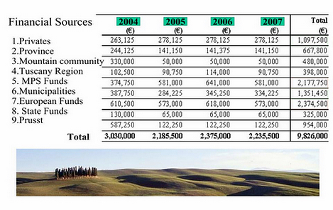
Figure 10: Overview of budget allocation, 2004-2007
Source: content from the PowerPoint of Professor Falini's lecture
3-3 Results of the plan's implementation
Result 1. Successful World Heritage nomination in 2004
The Val d'Orcia was officially inscribed as a World Heritage site in 2004, belonging to the cultural landscape category within cultural heritage, meeting inscription criterion (iv): an outstanding example of a Renaissance landscape; and inscription criterion (vi): paintings since the Middle Ages record the testimony of rural development. [Note 12]
The World Heritage core zone covers an area of 61,188 hectares, and the buffer zone covers 5,660 hectares; the extent is shown in Figure 11: the core zone includes 0.59% urban area, 62.82% agricultural area and 36.5% semi-natural area.
The description on the official UNESCO website repeatedly emphasizes that the historical agricultural landscape is precisely the key player in the nomination: to reflect the idealised model of good governance and to create an aesthetically pleasing picture, the area was replanned and developed in the 14th and 15th centuries when it was incorporated into the territory of the city-state. (...) It is a testimony to the well-managed agricultural beauty of the Renaissance. The sites inscribed on the World Heritage List include: the pastoral landscape reflecting a creative land management system, the towns and villages, the ancient Via Francigena leading to Rome and the abbeys, inns, sanctuaries and bridges along it.

Figure 11: Core zone and buffer zone of the World Heritage Val d'Orcia
Map by: H.J. Lin. Base maps: left - Nomination file of Val d'Orcia, right - UNESCO WHC
Result 2. Local agriculture upgraded, all farmland cared for
Actively supporting local toxin-free agriculture, organic farming and handicrafts meant that agricultural land was no longer left desolate, every plot of farmland had a farmer returning home to care for it, and the value of agricultural products gradually rose; in the end all wasteland disappeared and there was no fallow problem.
At the same time, high-quality local specialty agricultural products and handicrafts were continuously developed and assistance was given to obtain certification; for example, wine obtained DOC certification and olive oil obtained IGP and DOP certification, while the cheese of Pienza is loved by Italians. These high-quality agricultural products were thus able to open up more sales channels.
Because the value of agricultural products rose, the value of farmland also rose. In 1996, the price of each hectare of farmland was about 7,500-15,000 euros; by 2004 it had risen to 20,000-25,000 euros. Among these, the "Brunello vineyard" reached a value of as much as 300,000 euros per hectare.
Result 3. Tourism revenue grew greatly
After ascending to World Heritage status, the rural tourism industry and farmhouse accommodation flourished, demand for lodging increased greatly, and forms of travel diversified (Figure 12). In the same period, tourism growth in the City of Siena, the capital of Siena province, was only 36%, while the number of tourists to the Val d'Orcia grew by 166% and revenue grew by more than 100%.
In 2004, according to a survey by the Italian environmental league, national GDP increased by 11%, while the GDP of the Val d'Orcia Park increased by 28%; the national employment growth rate was 9%, while that of the Val d'Orcia reached 21%, becoming a model of economic development for all of Italy within just a few years. Under the European debt crisis, the Val d'Orcia did not take tourism as its orientation, and its industrial economy relied only on local agriculture and handicrafts, yet it became a safe haven.
Figure 12: Diversification of travel forms
Source: content from the PowerPoint of Professor Falini's lecture
Result 4. Cultural identity, young people spontaneously returning home
Young people who had originally migrated to big cities to strive for a living saw that local agriculture and tourism were generating good revenue, that every plot of farmland was more valuable, and felt a share in the honour; young people began to return home spontaneously to develop, to care for their own elders, and also developed more identification with the area, at the same time solving the previously serious problems of outmigration and population ageing.
Result 5. Resident participation and local basic education
In the earlier stage, various forms of resident participation were used to build consensus and eliminate conflict. In the later stage, standing on sufficient local identification, children's education was strengthened, letting primary school students learn about local industries and landscapes, and holding a "cultural heritage festival" belonging to children; it did not require much funding, yet it could at the same time prompt adults naturally to take part as well in order to look after the children.
One interesting project was to ask the children to go home and interview their grandparents, serving as recorders, writing down the elders' descriptions of how they played and lived on the land when they were young. In the end these were compiled and published, becoming a set of books that most truthfully record the hometown's history and emotional attachment to the land, letting the children and adults of every household become the protagonists and enjoy themselves, while in the process naturally deepening residents' feelings for the people, affairs and things of their hometown.
Result 6. Replacing expansion with restraint, maintaining local scale, promoting community solidarity
After the successful World Heritage nomination, the economic level was excellent, which of course attracted many covetous parties and speculators hoping to expand the urban area and attempting to use large-scale development proposals to attract more tourists.
But the five small towns had already foreseen the consequences, understanding that after urban expansion and a doubling of tourism, the old urban districts would face the possibility of damage from an unbearable new pressure, leading to a decline in the quality of life and tourism, and ultimately perhaps even driving local people out, changing the whole environment for the worse and staging the repeated decline drama seen in many tourist attractions.
Therefore, the five towns promoted a second-stage management plan. In order to continue maintaining the correct goals of the first stage, they decided to boldly and explicitly stipulate a reduction of the urban area, replacing expansion with restraint, blocking many development proposals that did not match the original intent, and preventing chain corporations and outside capital from entering and destroying local small-scale agriculture and handicrafts. In addition, they restricted land speculation and speculative development, did not encourage the building of new structures, and instead encouraged residents to discover the original value of old spaces and recover local treasures lost to time. (Figure 13)
The local government and residents of the Val d'Orcia did not, upon seeing advantage, rejoice and keep raising the stakes, but soberly insisted that everything return to humanistic values, not developing for the sake of tourism development, always leaving opportunities to local people. This approach indeed effectively put an end to speculation and also made the local community more united.

Figure 13: Va; d’Orcia, with development restrained to a moderate degree
Source: content from the PowerPoint of Professor Falini's lecture
Part Four. Lessons from an Agriculture-Based Approach
1. Starting sustainable development from grassroots farmland
Italy and Taiwan are similar in many social conditions: urban expansion, landslides and mudslides, desolate farmland... problems keep arising, land in big cities is full of speculation, and the countryside faces the normal condition of population ageing. The growth of the Val d'Orcia was by no means easily obtained by waiting idly for a rabbit to run into a tree stump.
The residents and local governments of the five small towns of the Val d'Orcia held firmly to the concept of "one great park," jointly protecting the Renaissance historical agricultural landscape, so that desolate farmland was cared for one plot at a time; with high-quality, land-friendly agricultural products and sufficient income, they successfully attracted young people to return and settle, solved the problem of outmigration, and also drove a series of rural tourism industries to flourish.
After smoothly being inscribed as a World Heritage site and becoming widely famous, they launched second-stage legislation to prevent large corporations from entering and depriving local small farmers and small enterprises of their livelihood, continuing toward the path of sustainable development of local industry.
This case, starting from the grassroots, highly dependent on agriculture yet turning toward high-benefit services, is low-carbon, energy-saving and economical, and by relying on such advantages it flourished amid the European debt crisis, flying high against the wind; this absolutely cannot be mentioned in the same breath as ordinary manufacturing development models, and is worth Taiwan's reference.
2. Bottom-up community participation energy
From beginning to end, the local government and residents of the Val d'Orcia walked ahead of the central government. Local areas best understand their own needs; the five local governments jointly promoted legislation and related plans from the bottom up, and also relied on education and communication to foster consensus within each community. This case powerfully proves the importance of "community participation" that European countries and World Heritage have repeatedly emphasized recently.
In 2005 the Council of Europe established the "Convention on the Value of Cultural Heritage for Society," also known as the "Faro Convention" (Convention on the Value of Cultural Heritage for Society, Faro, 2005), actively calling for the belief that the right to access heritage is a basic human right, encouraging people to move toward heritage, for heritage is not the exclusive asset of those in power; in 2008, the World Heritage Committee resolved to list Community as the fifth C of implementation goals [Note 13], emphasizing the importance of universality, participation and cooperation, and also hoping to strengthen interaction between World Heritage sites and related communities. In June 2012, the World Heritage conference further set the research theme of its 40th anniversary celebration as "World Heritage and Sustainable Development: the Role of Local Communities" (Figure 14).
For communities near and far, the energy that triggers participation absolutely cannot be achieved overnight. In Taiwan, the "community building" and "rural regeneration" related plans of various counties and cities are loudly proclaimed, and a small number of communities have grown stronger through years of empowerment. The blueprints drawn up are always beautiful, but unfortunately at the implementation end, outside teams sometimes come in with a single project's funding, pass through a single community, and then leave on their own, falling into a situation of seeing the trees but not the forest. Also constrained by administrative divisions, one rarely sees the grand ambition of cross-county and cross-city cooperation to protect cultural heritage; one hopes that in the future interesting policies and actions will emerge that connect points into lines and weave them into a surface.
Figure 14: 2012, the 40th anniversary of World Heritage
Theme: "World Heritage and Sustainable Development: the Role of Local Communities"
Source: UNESCO World Heritage website
3. The infinite possibilities of agricultural heritage
With great creativity, it was named "one great park"; the concept, development and management of the Val d'Orcia all transcended the traditional limited understanding of cultural heritage as the conservation of a single building or the scope of a cultural landscape, and expanded its care to the entire regional environment and living system, seeming to be a classic work of World Heritage cultural landscape and an ideal model fully embodying the organic interaction between humanity and the environment.
Moreover, the landscape aesthetics and comprehensive management thinking that the Val d'Orcia keeps constantly in mind have already opened a new page in the understanding of agricultural heritage, and may prompt the World Heritage WH and Globally Important Agricultural Heritage Systems GIAHS systems to place even greater emphasis in the future on so-called historical landscape value, overall environmental aesthetics, and the community vitality of sustainable development.
Conclusion: The farmstead and rural realm is the cultural landscape heritage that lies close to the earth from eternity
Looking across the globe, agricultural landscapes have already joined the international cultural heritage value chain, opening up brand-new interpretation and practice.
Looking back at Taiwan's countryside, if both the central and local governments are gradually losing the ambition to value "overall" agricultural value and always take "development" as their expectation for the future, then how can agricultural cultural heritage be handed down to the next generation in a broad and comprehensive way? How can the marvellous agricultural value that neither industry nor commerce can replace be highlighted as a whole? How can it be recognised what agriculture ought to do, and agricultural policies be formulated that do not develop because of tourism or land speculation? How can the irreversible situation in which farmland is constantly damaged by fallowing and expropriation be halted on a large scale? How can the value of agricultural products be raised as a whole and farmers' self-identification be enhanced?
The life of tilling the soil and supporting oneself, the farmstead and rural realm of "bright moonlight shining among the pines, clear springs flowing over the stones," is the cultural landscape heritage that lies close to the earth from eternity. Let us all cherish Taiwan's agricultural heritage and cultural landscape well; as long as the strategy is right, agriculture is absolutely not a drag on economic development. This is what the Italians tell us. (Figure 15)

Figure 15: Cherish Taiwan's agricultural heritage landscape
Source: H.J. Lin
[End of full text]
References:
1. GIAHS Globally Important Agricultural Heritage Systems official website: http://www.fao.org/nr/giahs/giahs-home/en/
2. Jokilehto, J. (2010) Reflection on historic urban landscapes as a tool for conservation. Managing Historic Cities. UNESCO WHC:Paris
3. Koohafkan, P. & Altieri, A. M. (2011) Globally Important Agricultural Heritage Systems: A Legacy for the Future. FAO:Rome
4. UNESCO World Heritage official website: http://whc.unesco.org/
5. Val d’Orcia World Heritage case file: http://whc.unesco.org/en/list/1026/documents/
6. Council of Agriculture, Executive Yuan websitehttp://www.coa.gov.tw/show_index.php
7. Lee Kuang-chung, 2009, Cultural Landscape and Community Development. National Science Council Science Development Monthly, 439: 38-45
8. Materials from Professor Falini of Italy's lecture at URS44 in Taipei on 2011.12.01 (special thanks to the assistance of the Taiwan Historical Resources Management Association)
[Note 1]
The author is rather dissatisfied with the simplified Chinese translation of Val d'Orcia on the official World Heritage website, "Cultural Landscape of the Val d'Orcia Park," since Val means valley and is not suitable for direct transliteration as "Val." Therefore, after reconsidering the most appropriate transliteration and hoping to express that this is a World Heritage cultural landscape case, it was decided to translate it as "Cultural Landscape of the Val d'Orcia." (Thanks here to "ItaliaOggi Today Italian Education Centre" for partial assistance.)
World Heritage is an international heritage selection system that stresses "Outstanding Universal Value," "Authenticity" and "Integrity" (OUV-AI) and requires an appropriate management system, much like the Nobel Prize or the Oscars in the film world. As of February 2012, the World Heritage list included 725 cultural heritage sites, 183 natural heritage sites and 28 mixed heritage sites, distributed among 153 of the 188 States Parties. (Please note that "World Heritage" does not include "intangible cultural heritage," which is often confused with it.)
The meaning of ‘landscape’ first appeared in 16th- and 17th-century Dutch painting (landskip, landschap, landscap, from Dutch) (Jokilehto, 2010:54), while the term cultural landscape was first proposed by a 19th-century German historian and a French geographer, and in the 1920s-30s was advocated by Professor Carl Sauer, a human geographer of the American Berkeley school (Lee Kuang-chung, 2009:39), gradually developing into other fields. In 1992, cultural landscape formally became a new type of cultural heritage within World Heritage, emphasizing the concept of the organic interaction between humanity and the environment and becoming the best intermediary under the sharp dichotomy between cultural heritage and natural heritage.
Currently on the World Heritage list there are roughly more than 70 cultural landscapes. The definition of cultural landscape is divided into three major categories: 1. landscapes intentionally designed or created by humans, including garden and park landscapes built for aesthetic reasons; 2. organically evolved landscapes, combined with the original social, economic, administrative or religious needs and developing to the present through connection with or adaptation to the surrounding natural environment. This is further subdivided into two types: (1) relic or fossil landscapes, (2) continuing landscapes closely combined with traditional social roles or ways of life, maintaining an active social function and at the same time presenting historical change in their own evolution; 3. associative cultural landscape, which emphasizes a strong connection with natural factors, religion, art or culture and does not take cultural physical evidence as its main feature.
[Note 2]
See Note 1
[Note 3]
For example, the International Council on Monuments and Sites (ICOMOS) set the theme of "International Cultural Heritage Day" in April 2010 as: agricultural heritage; in October of the same year, the annual conference held in Canada also took "conserving agricultural heritage" as its main axis of discussion.
[Note 4]
The official name of the 1972 "World Heritage Convention" is the Convention Concerning the Protection of the World Cultural and Natural Heritage, unanimously adopted at the UNESCO headquarters in Paris on November 16, 1972, and formally entering into force on December 17, 1975. The first batch of World Heritage sites was produced in 1978, opening a fervent global movement for the protection of cultural and natural heritage.
The content of the "World Heritage Convention" defines the types of heritage and also sets out in detail the responsibilities and obligations of each State Party to protect heritage, which must protect World Heritage within its territory through various relevant domestic and international legal, administrative, educational and communication means.
[Note 5]
Professor Paola E. Falini teaches in the Department of Urban Planning at the School of Architecture of Sapienza University of Rome. She has participated in the nomination work of many World Heritage sites and is currently involved in the "Greater Rome Plan," serving as an overall planning consultant for the city of Rome and Assisi, assisting in formulating the Assisi cultural landscape regulations, the Sabbioneta ancient city wall plan, the Mantua lake cultural park plan and the Mantua metropolitan open space regulations, among others.
[Note 6]
The 2012 World Heritage conference will be held in St. Petersburg, Russia, and the research theme of the 40th anniversary celebration is "World Heritage and Sustainable Development: the Role of Local Communities" (’World Heritage and Sustainable Development: the Role of Local Communities”).
[Note 7]
See Note 1
[Note 8]
See Note 1
[Note 9]
The selection criteria of GIAHS are divided into three major categories targeting the industrial system, the development context and actual implementation. The evaluation criteria for the industrial system are: "outstanding characteristics," "credible sustainability" and "global significance"; the evaluation criteria for the development context are: "representativeness," "external threats" and "relevance to policy and development"; the evaluation criteria for actual implementation are divided into: "integrity," "financing capacity" and "implementation methods."
[Note 10]
As of February 2012, GIAHS had listed ten pilot systems: Andean Agriculture (Peru), Chiloé Agriculture (Chile), Ifugao Rice Terraces (Philippines), Oases of the Maghreb (Algeria, Tunisia), Rice-Fish Agriculture (China), Hani Rice Terraces System (China), Wannian traditional rice culture system (China), Pastoral and Upland Agroecosystem (Kenya, Tanzania), Noto, Satoyama and Satoumi (Japan) and Sado, Satoyama (Japan).
There are another nine candidate systems, namely: Milpa-Solar Systems (Mexico), Chinampa Agricultural System (Mexico), Lemon Gardens (Southern Italy), Traditional Agro-Ecosystems in the Carpathians Region, Traditional Agriculture in the Koraput Region (Orissa – India), Soppina Bettas Systems (Western Ghats – India), Qanat Irrigation Systems and Homegardens (Iran), Qashqai Nomadic Pastoralism (Iran) and Wewe Irrigation System (Sri Lanka)
Agricultural heritage that has simultaneously obtained both World Heritage inscription and GIAHS cross-certification currently numbers an estimated five: Anuradhapura Wewe Irrigation System Sri Lanka (candidate), M’Zab Valley Oases of the Maghreb Algeria/Tunisia (pilot), Mexico City The Chinampa Agricultural System Mexico (candidate), Rice Terraces of the Philippine Cordilleras Ifugao Rice Terraces Philippines (pilot) and Shushtar Qanat Irrigation Systems and Homegardens Iran (candidate).
[Note 11]
Nearly 400 million New Taiwan dollars. Such a budget, compared with Taiwan's "rural regeneration plan" or "community building" and other related plans, appears very low, yet it achieved astonishing results.
[Note 12]
There are ten World Heritage inscription criteria in total, of which the first six apply to cultural heritage and are listed as follows:
1. to represent a masterpiece of human creative genius;
2. to exhibit an important interchange of human values, over a span of time or within a cultural area of the world, on developments in architecture or technology, monumental arts, town-planning or landscape design;
3. to bear a unique or at least exceptional testimony to a cultural tradition or to a civilization which is living or which has disappeared;
4. to be an outstanding example of a type of building, architectural or technological ensemble or landscape which illustrates (a) significant stage(s) in human history;
5. to be an outstanding example of a traditional human settlement, land-use, or sea-use which is representative of a culture (or cultures), or human interaction with the environment especially when it has become vulnerable under the impact of irreversible change;
6. to be directly or tangibly associated with events or living traditions, with ideas, or with beliefs, with artistic and literary works of outstanding universal significance. (The Committee considers that this criterion should preferably be used in conjunction with other criteria).
[Note 13]
2002 was the 30th anniversary of the "World Heritage Convention," when the "Budapest Declaration" proposed four Cs as the four future goals of World Heritage, including: 1. strengthen the "Credibility" of the World Heritage List to ensure that all World Heritage sites are highly representative, 2. promote effective "Conservation" of World Heritage, 3. enhance relevant "Capacity-building" of States Parties to ensure the quality of management personnel and techniques, 4. promote public understanding and support of World Heritage through various "Communication" channels. By 2008, a fifth C, "Community," was added, calling for the importance of universality, participation and cooperation.