Chiayi County Government introduces agricultural aerial photography for disaster loss assessment, taking only nine days
Whenever a typhoon or torrential rain strikes, farmers not only watch their lodged rice and silently ask heaven why, but also have to wait 2 or 3 months while the township office and county government conduct repeated on-site surveys before they can receive compensation. This drawn-out process consumes a great deal of manpower and resources. Last year, the Chiayi County Government cooperated with a private company and National Chung Hsing University to trial the use of unmanned aerial vehicles to photograph rice paddies before and after torrential rain, comparing the normal growth height of the rice to determine lodging conditions. It is estimated that it takes only 9 days to complete disaster damage surveys, and in the future this could be further extended to other crops, greatly improving the administrative efficiency of disaster damage subsidies.
Aerial photography of rice lodging, disaster damage surveys take only 9 days
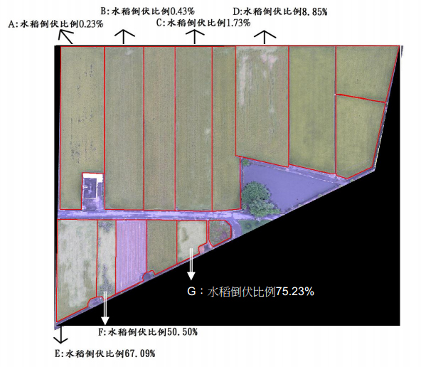
On June 3 last year, torrential rain suddenly fell across Taiwan, and much of the first rice crop that was about to be harvested lodged. While township offices and county governments across Taiwan were busy working overtime to survey the affected area, the Chiayi County Government launched unmanned aerial vehicles on June 7 to photograph rice paddies along the high-speed rail line, overlay cadastral photos and data, and analyze the normal growth height of the rice. It immediately identified 7.5% of rice paddies as lodged, and even accurately marked the lodging ratio and range of each field.
In recent years, unmanned aerial vehicle aerial photography technology (Unmanned Aerial Vehicle, UAV for short) has gradually become popular in Taiwan, but it is mostly used to build landscape data and collect footage for newspapers and television stations, and is rarely used in agriculture. Last year, the Chiayi County Government launched a cooperative project with a private company and the Disaster Prevention Technology Research Center of the Environmental Protection Planning Disaster Prevention Center at National Chung Hsing University to apply UAV technology to agricultural natural disaster compensation, surveys for activating fallow land programs, and oyster rack identification. The results greatly amazed the county government.
According to Article 14 of the Agricultural Natural Disaster Relief Measures, if farmers suffer a natural disaster and wish to receive compensation, they must first report it to the local township office. The township office conducts a preliminary survey of the extent of the damage, and then the local government launches a survey team to coordinate with the township office, improvement station, Agriculture and Food Agency, and others for on-site surveys. If the damage reaches 20%, the county government submits it to the Council of Agriculture, and only after public announcement can compensation be confirmed. It also still has to pass spot checks by the survey team, and back and forth it takes at least several months.
Li Qiuying, section chief of the Agricultural Affairs Section of the Chiayi County Agriculture Department, gave an example. On June 9, 2012, Typhoon Talim struck. The township office launched an on-site survey on June 23, and on July 4 the Council of Agriculture approved a special subsidy. Farmers reported the affected area, and surveys were carried out at the same time. It was not until August 30 that all application materials were sent to the Agriculture and Food Agency, and the funds were disbursed on September 19, taking more than 3 months in total, and this was only the survey for one township, Puzi.
If manual surveys are not fast enough, farmers may be unable to resume cultivation. In disputed cases, the lack of sufficient before-and-after comparison images also leads to each side giving its own account. The Chiayi County Government estimates that if UAV technology is used, it would take only 9 days to complete all disaster damage assessments, and in addition to taking photographs, it can automatically analyze objects in the landscape. For example, normal rice paddies appear bright green, lodged rice appears red, man-made structures appear gray, and fallow land appears yellow.
Li Qiuying said that current surveys mostly involve taking photographs on site, but the angle is limited and it is difficult to see the entire rice paddy area. UAVs photograph from above, which is relatively more objective, and also saves the manpower and resources of repeated disaster surveys, greatly helping the construction of basic data.