Super El Niño to bring strong floods and weak droughts this summer
Original title: Will this summer bring "rainy floods and unusual heat"?
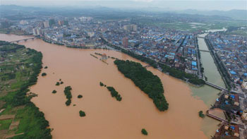
On May 21, the Xiao River in Dao County, Yongzhou, Hunan, exceeded the warning water level by 2 m in the county seat section of Dao County. (Online illustration: Xinhuanet, photo by He Hongfu, Xinhua News Agency)
According to analysis by meteorological departments, affected by the super El Niño that will continue to weaken, relatively severe flooding may occur this summer. So will "rainy floods and unusual heat" reappear? And what should be noted in agriculture? On May 21, the reporter interviewed Huang Zhimin, a senior agricultural meteorology engineer and an expert receiving special government allowances from the State Council.
Huang Zhimin said that if one checks the meteorological data, one will find that from January to early May this year, temperatures in some areas of the middle and lower reaches of the Yangtze River remained persistently high. In Jingzhou City, located in the middle reaches of the Yangtze River, in terms of the average temperature for each ten-day period, among these 13 ten-day periods, except for the late ten days of January, which was lower than the same period in previous years, the other 12 ten-day periods were all higher than the same period in previous years. Since the city began regular meteorological records in 1954, this is unprecedented. In 2004, the only year close to it, the ten-day temperature distribution before and during late April was basically the same, but by early May it began to be 1.4°C lower. From January 1 to May 10 this year, the accumulated daily average temperature reached 1536.8°C, 122.6°C higher than the average accumulated temperature for the same period in previous years. It can be seen that both the number of ten-day periods with higher temperatures and the accumulated temperature during this period this year rank first.
The emergence of the above "low-probability event" should be caused by global climate warming. The persistently high temperatures in this region from January to early May this year covered both a warm winter and rapid spring warming, which correspondingly increased the water vapor content in the air. This was the reason for the continuous severe precipitation that occurred in some southern regions in April. Of course, it was also the result of the combined effect with cold air moving south from the north.
So will the above extreme conditions have any adverse effects on this summer's weather?
In terms of the characteristics and patterns of historical weather and climate change, there is the characteristic of monsoon climate with rain and heat in the same season, and there is also the general rule that changes in the sliding quantities of meteorological elements move from quantitative change to qualitative change. At the same time, research by the Jingzhou Agricultural Meteorological Experiment Station of the China Meteorological Administration shows that despite global climate warming, in recent years low-temperature cold damage in the middle and lower reaches of the Yangtze River, where the daily average temperature is below 23°C for 3 consecutive days or more, has actually increased. For example, from January to late April 2004, after such persistently high ten-day temperatures occurred, the following important agricultural meteorological events occurred in Jingzhou City:
First, during the booting stage of early rice in June, there was a "Grain in Ear cold" with daily average temperatures below 22°C for 4 consecutive days, which can easily cause partial pollen sterility and lead to a reduced seed-setting rate.
Second, during the heading and flowering stage of middle rice in midsummer in August, there was low-temperature cold damage with daily average temperatures below 23°C for 4 consecutive days, which can easily cause poor pollination and fertilization and reduce the seed-setting rate; cotton suffering from cloudy, rainy and cold damage will increase the rate of bud and boll shedding.
Third, the reason the above cold damage occurred is that precipitation from June to August was significantly higher than usual, with precipitation in both June and August above 200 mm, and multiple rainstorms with daily amounts of 50 mm or more.
Coincidentally, the above analysis is fairly consistent with the view of some experts in meteorological departments that, under the influence of the super El Niño that will continue to weaken, this year's floods will be heavier than droughts. Therefore, this year it is necessary not only to strengthen defenses against possibly relatively severe flood disasters, but also to guard against disasters likely to occur in flood years, such as low-temperature cold damage to early and middle rice and cotton, rice planthoppers, sheath blight, rice blast, and verticillium wilt. (Reporter Liu Zhiwei for this newspaper)