Tropical depression brings rain to Guangdong, 19 cities and counties issue typhoon warnings
Original headline: Heavy rain approaching, 19 cities and counties in Guangdong issue typhoon warnings
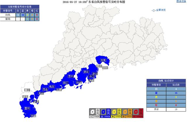
10:59 2016-5-27 Real-time distribution map of typhoon warning signals in Guangdong Province (Network illustration: Guangdong Provincial Meteorological Bureau)
The reporter learned from the Guangdong Provincial Flood Control and Drought Relief Headquarters that the monsoon cloud cluster originally over the sea surface near the Xisha Islands developed into a tropical depression at 14:00 on May 26, and is expected to make landfall along the coastal area from Jiangmen to Maoming between noon and the first half of the night on May 27, bringing a new round of heavy rainfall. The provincial government attaches great importance to the current defense work. Vice Governor and Commander-in-Chief of the Provincial Flood Control and Drought Relief Headquarters Deng Haiguang instructed that all localities and departments must carefully deploy, implement the main responsibilities of each locality, and refine contingency plans and measures to ensure the safety of people's lives and property. The Provincial Flood Control and Drought Relief Headquarters issued a notice on May 26, requiring all localities to strengthen duty shifts and on-call staffing, and to activate emergency responses in a timely manner in accordance with the plans.
According to monitoring, at 14:00 on the 26th, the center of the tropical depression was located on the sea surface of the northwestern South China Sea, about 440 kilometers east-southeast of Yangjiang, with a maximum wind force near the center of force 6 (12 m/s). It is expected to move northwestward at a speed of 15 to 20 kilometers per hour, maintain or slightly increase in intensity, and make landfall along the coastal area from Jiangmen to Maoming at tropical depression intensity between noon and the first half of the night on the 27th. Affected by this, from the night of the 26th to the daytime of the 27th, cities and counties in western Guangdong, eastern Guangdong, and southern parts of the Pearl River Delta will experience heavy rain to rainstorms with localized severe rainstorms, accompanied by short-duration gales of force 8 or above during thunderstorms; from the night of the 27th to the 28th, most cities and counties in western Guangdong will have moderate to heavy rain with localized rainstorms, among which Maoming Xinyi will have heavy rain to rainstorms from the afternoon of the 27th to the evening of the 28th.
Yangcheng Evening News reporters noted that as of 0:02 today, 19 cities and counties in Guangdong, including Yangjiang, Taishan, Zhanjiang, Shenzhen, Zhongshan, and Zhuhai, had issued typhoon warning signals.
The Provincial Flood Control and Drought Relief Headquarters emphasized that the situation for disaster prevention and resistance across the province, especially in western Guangdong and northern Guangdong, which were more severely affected earlier, will become more severe. All localities and relevant departments must strictly implement the 24-hour duty system and implement various targeted defense measures in advance. Coastal areas west of Shanwei must strengthen safety supervision of fishing boats operating in affected sea areas, tourism, angling, leisure and other vessels, personnel working at sea such as aquaculture workers, and tourists in coastal scenic areas.
Guangzhou weather reminder
Today and tomorrow, affected by the tropical depression, the whole city will have a precipitation process of heavy rain with localized rainstorms, accompanied by lightning and short-duration gales of force 8 to 9; wind force at Guangzhou Port will gradually increase to force 5 to 6, with gusts of force 7. (Yangcheng Evening News report by reporters Zhang Aili and Liu Yong, correspondent Yue Shuixuan)
Related links>>>
First tropical cyclone of the year expected to make landfall in Guangdong today, typhoon season has arrived
The reporter learned from the Guangdong Provincial Meteorological Observatory that the first tropical cyclone of the year is expected to make landfall along the coast from Jiangmen to Maoming in Guangdong on the 27th. Affected by it, cities and counties in western Guangdong, eastern Guangdong, and southern parts of the Pearl River Delta will have heavy rain to rainstorms with localized severe rainstorms, bringing Guangdong its third wave of heavy rainfall since May.
Lu Shan, chief forecaster of the Guangdong Provincial Meteorological Observatory, said that the monsoon cloud cluster originally over the sea surface near the Xisha Islands developed into a tropical depression at 14:00 on the 26th. A tropical depression is the lowest category of tropical cyclone; once it strengthens into a tropical storm, it becomes a "typhoon."
The meteorological department estimates that the tropical depression will move northwestward, maintain or slightly increase in intensity, and make landfall at tropical depression intensity along the coast from Taishan, Jiangmen to Dianbai, Maoming between noon and the first half of the night on the 27th, then weaken rapidly after landfall. Affected by it, from the night of the 26th to the 28th, cities and counties in western Guangdong, eastern Guangdong, and southern parts of the Pearl River Delta will have a rainfall process of heavy rain to rainstorms with localized severe rainstorms, and wind force over the coastal waters of Guangdong Province and the northern South China Sea will gradually increase to force 5 to 7. This rainfall process will become the third wave of heavy rainfall to hit Guangdong since May. (According to Xinhua News Agency, Shenzhen Metropolis Daily 2016-05-27 08:20)
"Typhoon embryo" to make landfall in Guangdong today, thunderstorms possible this weekend
For the next three days starting today, Xiamen's air will be humid, with the highest temperature reaching 30°C, and it may feel somewhat muggy.
Over the past two days, the subtropical high, this great furnace, has fully controlled Fujian, continuously pushing temperatures up. Yesterday (the 26th), the highest temperature in Xiamen's urban area climbed to 30.4°C, and the highest temperatures in Wuxian Town in Tong'an and Mianqianpu Village in Xiang'an both soared to 33.3°C. Coupled with persistently high air humidity, midday became as muggy as being steamed.
Right now, a tropical cloud cluster is lingering over the South China Sea, constantly approaching land. We can regard it as a typhoon embryo, but it is still far from truly forming a typhoon. This cloud cluster will make landfall in Guangdong today, bringing heavy rain or even rainstorms to the area. Xiamen will be "brushed" by the outer rainbands of this cloud cluster, with showers or thunderstorms appearing, and localized areas may have heavy rain. The rain cannot extinguish the steaming heat, and today's temperatures will remain on the high side, with the highest temperature in the urban area still climbing to 30°C, and the lowest temperature at night and in the morning around 25°C.
Tomorrow and the day after (the 28th-29th), the subtropical high, this great furnace, will be somewhat caught between advancing and retreating, first weakening and retreating southward, then quickly strengthening, extending westward and moving northward. During this process, Xiamen will always be affected by southwesterly airflow, with humid air and weather mainly cloudy to overcast with showers or thunderstorms. Temperatures will not change much, and the highest temperature can still reach 30°C. (Xiamen Net - Xiamen Daily report by reporter Yin Lei, correspondent Xiao Wang)