La Niña phenomenon arrives, China's climate similar to 1998
Original title: El Niño "retires" but does not "fade"
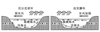
El Niño and La Niña (network illustration)
On June 3, at the Duliu River Grand Wharf in Congjiang County, Guizhou Province, some vehicles were submerged by floodwaters. (Network illustration: Xinhua Net)
As early as the beginning of this year, meteorologists predicted that this super-strong El Niño event might end by the end of May. And at the regular press conference held by the China Meteorological Administration on June 3, the news of El Niño's "retirement" was finally officially announced.
However, meteorologists remind that although El Niño has "retired," it will not easily "fade," and its influence will still run through the entire flood season. The Yangtze River, Songhua River, Huai River, Xijiang River and other river basins still have alarm bells ringing.
Can be called the "strongest in history" El Niño
This El Niño event began in September 2014. After more than a year of "baptism," the public is no longer unfamiliar with El Niño events. This phenomenon of large-scale sustained abnormally warm seawater occurring in the central and eastern equatorial Pacific may, through the interaction of atmospheric circulation systems, have a profound impact on the global climate.
Looking back at history, since 1951, a total of 14 El Niño events have occurred globally, of which 3 reached super-strong levels, namely the 1982/1983 El Niño event, the 1997/1998 El Niño event and this event.
Song Lianchun, director of the National Climate Center, pointed out that this event "comprehensively surpassed" the previous two super-strong El Niños in indicators such as peak intensity, duration, cumulative sea temperature anomaly, and the number of consecutive months with anomalies exceeding 2.0°C, and can be called the "strongest in history" El Niño.
For China, since our country is a typical monsoon climate country, the biggest characteristic is the large interannual variability of precipitation. Under abnormal sea temperature conditions, the variability will be even more significant. Under the effect of El Niño, an anticyclonic high-pressure circulation system from the Philippines to the South China Sea can be triggered. This circulation system superimposes on the subtropical high, making the western Pacific subtropical high stronger in intensity and more southerly in position, which is not conducive to the movement of the rain belt during the flood season.
In other words, under the influence of El Niño, the "rain god" may visit a specific region more "single-mindedly," causing the probability of major floods in that region to rise rapidly.
Judging from the catastrophic flood in the Yangtze River basin in 1998, it was precisely because the entire rain belt kept raining around the Yangtze River during the flood season that the Yangtze River flood formed a "peak after peak" situation, causing major dangers in the basin.
The whole country may see "floods at both ends and drought in the middle"
Since the start of the flood season, southern China has experienced more than ten rounds of heavy rainfall, with a frequency and intensity rarely seen.
According to statistics from the Office of the State Flood Control and Drought Relief Headquarters, precipitation since the start of the flood season has been the second highest in nearly 55 years, with some areas in Jiangnan, South China, Southwest, Northwest and Northeast China experiencing 30 percent to 100 percent more. Floods exceeding warning levels occurred in 118 rivers including the Xiangjiang River in Hunan, the Ganjiang River in Jiangxi, the Beijiang River in Guangdong, the Guijiang River in Guangxi and the Minjiang River in Fujian, the most for the same period in nearly 5 years.
The reporter learned from the National Meteorological Center that this year the South China Sea summer monsoon broke out at the end of May, which means that the transport of water vapor from the southwest has significantly strengthened. The low-level southwesterly winds will continuously transport abundant water vapor from the tropical ocean to the East Asian continent, and the monsoon rain belt will gradually advance toward central and eastern China, and our country will fully enter the main flood season.
The latest forecast from the Office of the State Flood Control and Drought Relief Headquarters shows that overall precipitation during this year's flood season will be above normal, and it specifically points out that major floods may occur in the Yangtze River, Songhua River, Huai River and Xijiang River, and the possibility of floods in other major rivers cannot be ruled out. At the same time, relatively severe drought may occur in North China and other areas. This means that during this year's flood season, the whole country may see "floods at both ends and drought in the middle," that is, southern and northeastern regions will suffer floods and waterlogging disasters, while North China will mainly experience drought. It is necessary to both prevent floods and fight drought, and the situation for flood control and drought relief is severe.
"So far, many climate phenomena similar to those of 1998 have occurred in the atmosphere. People need to use 1998 as a standard, prepare to cope with major floods, and fight a hard battle to overcome possible floods in the Yangtze River basin," said Zhou Bing, chief expert in climate monitoring at the National Climate Center.
La Niña "takes the baton" from El Niño
Monitoring by climate experts shows that cold water in the central and eastern equatorial Pacific is currently developing rapidly. If the extent and duration of seawater cooling reach a certain critical value, it may trigger the opposite of El Niño - the La Niña phenomenon.
The harm of La Niña is usually weaker than that of El Niño, but the impact of La Niña events over the past nearly 60 years shows that after La Niña occurs, autumn rain in some parts of China is above normal, while in winter most of the country mainly has below-normal precipitation and lower temperatures. Although the La Niña phenomenon may not directly affect the main flood season, its impact on later climate trends cannot be ignored.
In addition to rainfall, El Niño also has an important impact on global agricultural production. Relevant experts from the China Meteorological Administration, based on comprehensive analysis of meteorological data, satellite remote sensing data and crop yield prediction models, believe that due to the impact of El Niño, meteorological conditions in many countries this year are unfavorable, and it is expected that both wheat in India and corn in Brazil may reduce production this year, thereby driving up international agricultural product prices.
For China, this is currently the summer harvest season. Experts suggest that in the face of the increasingly severe weather situation during the main flood season, all summer harvest areas need to seize the gaps between rainfall, harvest and dry in time, and ensure that every grain is safely stored. (Xinhua News Agency reporters Lin Hui, Yu Wenjing)